Difference between revisions of "Google Maps"
| Line 1: | Line 1: | ||
== Geocoder == | == Geocoder == | ||
Generates lat and long: http://itouchmap.com/latlong.html | Generates lat and long: http://itouchmap.com/latlong.html | ||
| + | |||
| + | == Google maps url == | ||
| + | |||
| + | Building a Google Street View URL | ||
| + | |||
| + | Basic Google Map URL http://maps.google.com/maps?q= | ||
| + | |||
| + | q= Query - anything passed in this parameter is treated as if it had been typed into the query box on the maps.google.com page. | ||
| + | |||
| + | Basic url to display GPS cords location | ||
| + | |||
| + | http://maps.google.com/maps?q=31.33519,-89.28720 | ||
| + | |||
| + | http://maps.google.com/maps?q=&layer=c | ||
| + | |||
| + | layer= Activates overlays. Current options are "t" traffic, "c" street view. Append (e.g. layer=tc) for simultaneous. | ||
| + | |||
| + | http://maps.google.com/maps?q=&layer=c&cbll= | ||
| + | |||
| + | cbll= Latitude,longitude for Street View | ||
| + | |||
| + | http://maps.google.com/maps?q=&layer=c&cbll=31.33519,-89.28720 | ||
| + | |||
| + | http://maps.google.com/maps?q=&layer=c&cbll=31.335198,-89.287204&cbp= | ||
| + | |||
| + | cbp= Street View window that accepts 5 parameters: | ||
| + | |||
| + | Street View/map arrangement, 11=upper half Street View and lower half map, 12=mostly Street View with corner map | ||
| + | |||
| + | Rotation angle/bearing (in degrees) | ||
| + | |||
| + | Tilt angle, -90 (straight up) to 90 (straight down) | ||
| + | |||
| + | Zoom level, 0-2 | ||
| + | |||
| + | Pitch (in degrees) -90 (straight up) to 90 (straight down), default 5 | ||
| + | |||
| + | The one below is: (11) upper half Street View and lower half map, (0) Facing North, (0) Straight Ahead, (0) Normal Zoom, (0) Pitch of 0 | ||
| + | |||
| + | This one works as is, just change the cords and if you want to face a different direction (the 0 after 11) http://maps.google.com/maps?q=&layer=c&cbll=31.335198,-89.287204&cbp=11,0,0,0,0 | ||
== centre pivot irrigation == | == centre pivot irrigation == | ||
Latest revision as of 08:19, 5 October 2013
Contents
Geocoder
Generates lat and long: http://itouchmap.com/latlong.html
Google maps url
Building a Google Street View URL
Basic Google Map URL http://maps.google.com/maps?q=
q= Query - anything passed in this parameter is treated as if it had been typed into the query box on the maps.google.com page.
Basic url to display GPS cords location
http://maps.google.com/maps?q=31.33519,-89.28720
http://maps.google.com/maps?q=&layer=c
layer= Activates overlays. Current options are "t" traffic, "c" street view. Append (e.g. layer=tc) for simultaneous.
http://maps.google.com/maps?q=&layer=c&cbll=
cbll= Latitude,longitude for Street View
http://maps.google.com/maps?q=&layer=c&cbll=31.33519,-89.28720
http://maps.google.com/maps?q=&layer=c&cbll=31.335198,-89.287204&cbp=
cbp= Street View window that accepts 5 parameters:
Street View/map arrangement, 11=upper half Street View and lower half map, 12=mostly Street View with corner map
Rotation angle/bearing (in degrees)
Tilt angle, -90 (straight up) to 90 (straight down)
Zoom level, 0-2
Pitch (in degrees) -90 (straight up) to 90 (straight down), default 5
The one below is: (11) upper half Street View and lower half map, (0) Facing North, (0) Straight Ahead, (0) Normal Zoom, (0) Pitch of 0
This one works as is, just change the cords and if you want to face a different direction (the 0 after 11) http://maps.google.com/maps?q=&layer=c&cbll=31.335198,-89.287204&cbp=11,0,0,0,0
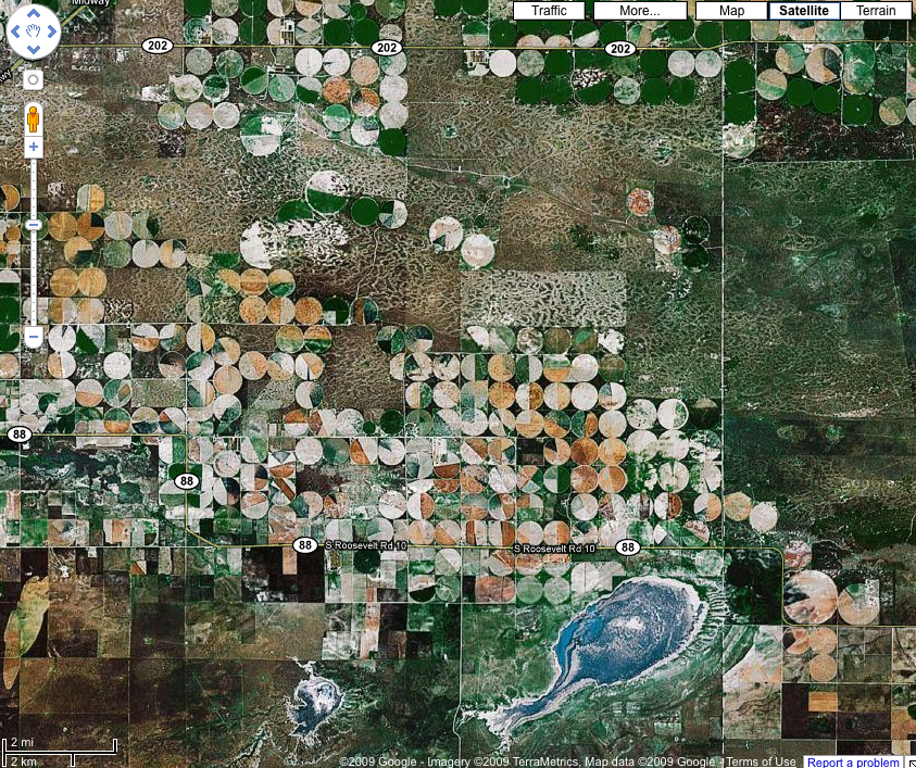
centre pivot irrigation
location: "clovis municipal airport"
Center-pivot irrigation (sometimes called central pivot irrigation), also called circle irrigation, is a method of crop irrigation in which equipment rotates around a pivot. A circular area centered on the pivot is irrigated, often creating a circular pattern in crops when viewed from above.
annotating google maps
- http://www.engadget.com/2005/03/08/how-to-make-your-own-annotated-multimedia-google-map/
- http://code.google.com/apis/maps/documentation/overlays.html
- http://esa.ilmari.googlepages.com/mymapsmarker.htm
- http://code.google.com/apis/maps/documentation/flash/tutorial-flex.html#DeclaringMaps
- http://www.opengreenmap.org/en/greenmap
