
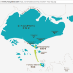
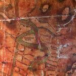
The estimated perimeter of Pulau Ubin is approximately 23km.
At an estimated rate of 1 hour per 5km, this endeavour would take at least 4.6 hour. Since I am very unfit, perhaps this will be closer to 5 hours or even 6 hours, while also having to find one’s way around as there is no actual footpath or route.
Next, I will be looking for cheap GPS real-time receiver and an old map of Singapore. A GPS receiver will be much more accurate than my iPhone and can be used to map out the actual route taken around Pulau Ubin. I would also be able to go geocaching or make up some geocache variant. Looks like prices are below SG$100 so its not a costly investment either.
The Global Positioning System uses a set of 27 satellites (24 are in use, 3 are backups) which orbits earth at about 19300km above ground. At any one time and from any location on earth, there will be at least 4 satellites within “visible” line-of-sight. The GPS receiver sends a signal trying to locate at least 3 of these satellites and from the signal it receives back from the satellites, it uses trilateration in 3d space to calculate the actual position of the GPS device on earth.
Related posts:
 Pulau Ubin – Chek Jawa Boardwalk
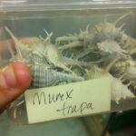 The Collectors of Pulau Saigon: Murex Trapa shells, and Pyrites (Fool’s Gold)
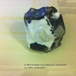 The Chert of Pulau Saigon, a former island in the Singapore River
 The Library of Pulau Saigon in “2219: Futures Imagined”: Animated GIF Workflow
 Pulau Semakau – Singapore’s First Landfill Island
 Bone, Metal, Wood, and Other Artefacts found on Pulau Saigon
 Pulau “Funtasy”: The Maritime Dispute between Singapore and Indonesia that Wasn’t
 Made-up Road Names and Temporary Islands