This weekend I was very fortunate to meet Mr KL Loh, a land surveyor who has been working for over 40 years in land surveying (and an avid collector of Killifish and moss expert!). He was very kind to invite me over to his house, and to tell me more about his work as a land surveyor, and we also looked through the symbols I’ve been collecting for the last few years. (Many thanks to Mr Loh and his family for having me over – and Caleb for introducing us in the first place!)
It was really really amazing to finally speak with a real land surveyor and to hear it directly from someone who makes official, practical marks which are being used in actual architectural and civil engineering projects in Singapore and we had many many urban stories or anecdotes to share and talk about. I will slowly process it all and write more about it in time to come.
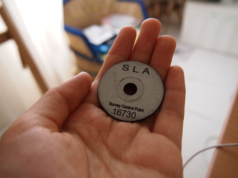
It appears that most of what I have been collecting is not always “survey markers” but also a lot of informal civil engineering markers. True survey markers always have a plate and a reference number. The number is stored inside a big database known as the Integrated Land Information Service and anyone can retrieve information from this service (such as property titles, boundary plans, cadastral maps, control points) for a small fee.
On INLIS, this is a list of information that is provided:
a. Property Title Information comprising title, ownership, encumbrances, last transaction information and Land Encroachment Details
b. Property Ownership Information
c. Property Title Information – Estate and Land Description
d. Property Title Information – Encumbrances Information
e. Property Title Information with Cadastral Map
f. Historical Information which lists instruments and caveats lodged against a title or unregistered land after it has been computerised
g. Caveat Index Information which lists caveats lodged and still affecting an unregistered land
h. Land Information – Lot Particulars
i. Land Information – Lot History
j. Encroachment Boundary Plan
k. Certified Plan
l. Strata Certified Plan
m. Registrar of Title Plan
n. Road Line Plan
o. Horizontal Control Point & Vertical Control Point
p. Image of HDB Leases
q. Image of HDB Instruments
r. Image of Private Property Instruments
s. Image of Index to Land Book
t. Image of Index to Caveat Book
u. Image of Private Property Deeds
Available Graphical Information (as listed on INLIS):
• Cadastral Map
• Property Title Information with Cadastral Map
• Road Line Plan
• Horizontal Control Point & Vertical Control Point
Some of the interesting things I learnt were that (1) the control points are also sometimes on turf and i have only collected ones on pavements but surveyed points sometimes aren’t always on concrete pavements or roads, and (2) the control points have the potential to go missing – KL said that many control points were made much more quickly in modern times, and as a result some of them would disappear after a few years. So when surveyors returned to look for them after many years (or when looking for other control points listed on INLIS) these points might have disappeared (soil movement might also cause their position to shift!). Apparently in the old days some of the control points were marked out with granite blocks and they were laid into the turf/ground with more time and care; a few still exist in older places such as Bukit Timah Nature Reserve and possibly Bukit Brown.
With regards to blocks that stick out on grassy turf… having read a book on LTA Guidelines recently, I have also realized that there is also much more to learn about those boxes and pipes we sometimes see on roads. I have frequently wondered why sometimes pavements have little metal boxes sticking out and it appears they are not all the same! Those little boxes or tubes serve very different purposes in monitoring different things. Here are diagrams of what some things that stick out from roads might be:
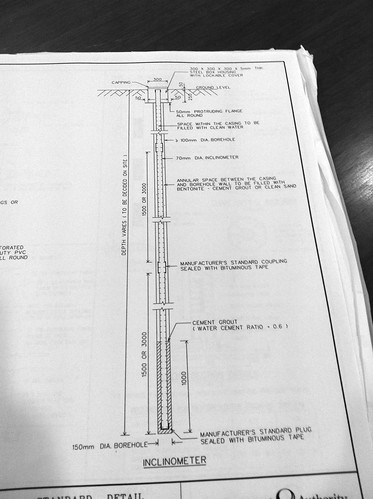
Inclinometer
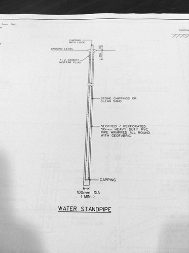
Water Standpipe
Related posts:
 Time for the Irresponsible Disposal of Confidential Documents!
 Welcome to 2012
 Istana Woodneuk
 Don Porfirio – El Senor de la Bestias
Yangtze Scribbler – Spotted again
Don Porfirio – El Senor de la Bestias
Yangtze Scribbler – Spotted again
 Geocoding: From the streets to Adobe Bridge and then Excel (Part I)
 Public Service Notice on Geodes, and Text Complexity
 Streetart Straße